Continued high precision measurements of Earth’s sea level is assured
The most accurate source of measurements of the Earth’s rising sea levels – the Jason-3 satellite mission – will continue for at least two more years from today after the extension of its mission.
January 17, Jason-3 celebrated the third anniversary of its launch after having orbited the Earth more than 14,000 times. But it’s not just any anniversary.
Today, Jason-3 closes its routine operations phase, having accomplished the primary goals defined by its American and European partners – EUMETSAT, the US National Oceanic and Atmospheric Administration (NOAA), the French Space Agency (CNES), NASA/JPL and the European Commission.
As the satellite and its instruments continue to perform extremely well, from today it enters its extended routine operations phase.
This terminology might not mean much to those outside the meteorological satellite sector, but the importance should not be overlooked. Barring unforeseen circumstances, at least two more years of highly accurate data crucial for climate change monitoring, weather forecasting and safety at sea, and many other applications, can be expected.
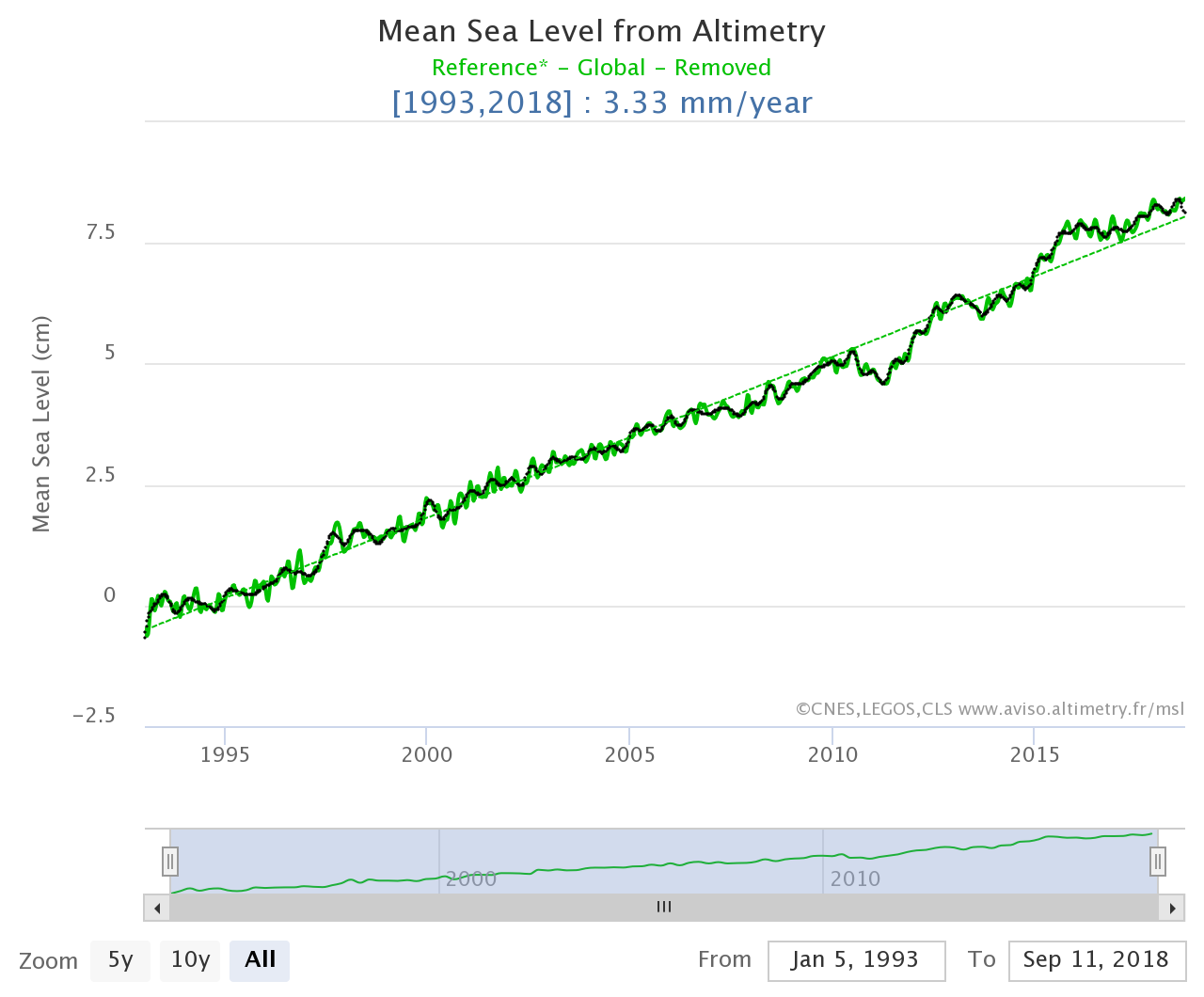
“Measurements from Jason-3’s altimeter are crucial for climate monitoring,” EUMETSAT Mission Scientist Remko Scharroo said. “Over the past 25 years, the Jason satellites and their predecessors have measured a mean sea level of rise of about 3mm per year. Recently, the first sign that the rise in the mean sea level rise is accelerating has been observed.
“Jason-3 is the current High Precision Ocean Altimetry reference mission and is functioning as the reference for other satellite altimeter missions, such as that of Sentinel-3.
“The marine meteorology community continues to benefit from high-quality wind speed and sea state measurements, which are key factors for improving complex computer modelling needed for weather prediction.
“And its sea level measurements are inputs for a host of operational ocean applications, such as ocean current monitoring conducted by Europe’s Copernicus Marine Environment Monitoring Service (CMEMS) and hurricane forecasting by NOAA’s National Hurricane Centre.”
Jason-3 is the continuation of an important US/European satellite series that has now been providing vital data on sea level rise and ocean circulation for more than 25 years. This series of satellite radar altimeters measures the peaks and troughs of the sea surface height, or surface topography of the world’s ice-free oceans, every 10 days.
The data time series began with the 1992 launch of the NASA/CNES TOPEX/Poseidon mission (1992-2006) and was continued by Jason-1 (2001-2013), and by Jason-2, which launched in 2008 and is still in operation. The latter is currently contributing to the generation of a high-resolution map of the mean sea surface.
“These important missions have provided researchers and society with a rich legacy of unprecedented ocean observations,” NASA/JPL Project Scientist Josh Willis said.
“Earth's oceans exert a powerful influence on global climate, and never before have we had such accurate observations of the rate of sea level rise and the change of ocean circulation over time, an important indicator of climate change.
“Data and images are available in near-real time for some uses and are used for a wide range of scientific as well as commercial and practical applications.
“Around the globe, operational weather agencies use Jason-3 data for climate forecasting. For many countries, these forecasts are crucial in planning for floods and drought, agricultural strategies and allocating water and energy use.”
With Jason-3 mission, the quality and precision of the products has kept on improving. As indicated by CNES project scientist Pascal Bonnefond : "Algorithms embedded on the Jason 3 mission were specifically designed to improve data quality in coastal areas, lakes and rivers. These are regions with significant socio-economic and climatic issues but poorly covered by standard altimetry data in the past. "
The Jason-3 mission is based on solid cooperation between the partners, which capitalises on the expertise of the different organisations and achieves financial efficiency by sharing costs.
The Jason-3 Joint Steering Group, with representatives of the mission partners, met in September 2018 and agreed to the extended routine operation phase after the initial three years of the routine operation phase. All parties also expressed their willingness to keep operations going beyond January 2021, should the satellite continue to perform well.
The long-term future of the high precision ocean altimetry mission is assured through the future Jason-Continuity of Service/Sentinel-6 mission. This is a programme composed of two successive satellites: Jason-CS A and Jason-CS B, with the first scheduled for launch in November 2020.
Jason-3 is expected to play a key role in the commissioning of Jason-CS A, allowing in-flight instrument cross-calibration.
The many significant scientific outcomes from these data include:
Measuring global sea level rise [link to https://www.aviso.altimetry.fr/en/data/products/ocean-indicators-product...
Mapping regional sea level variations [link to https://www.aviso.altimetry.fr/en/applications/ocean/mean-sea-level-gree...
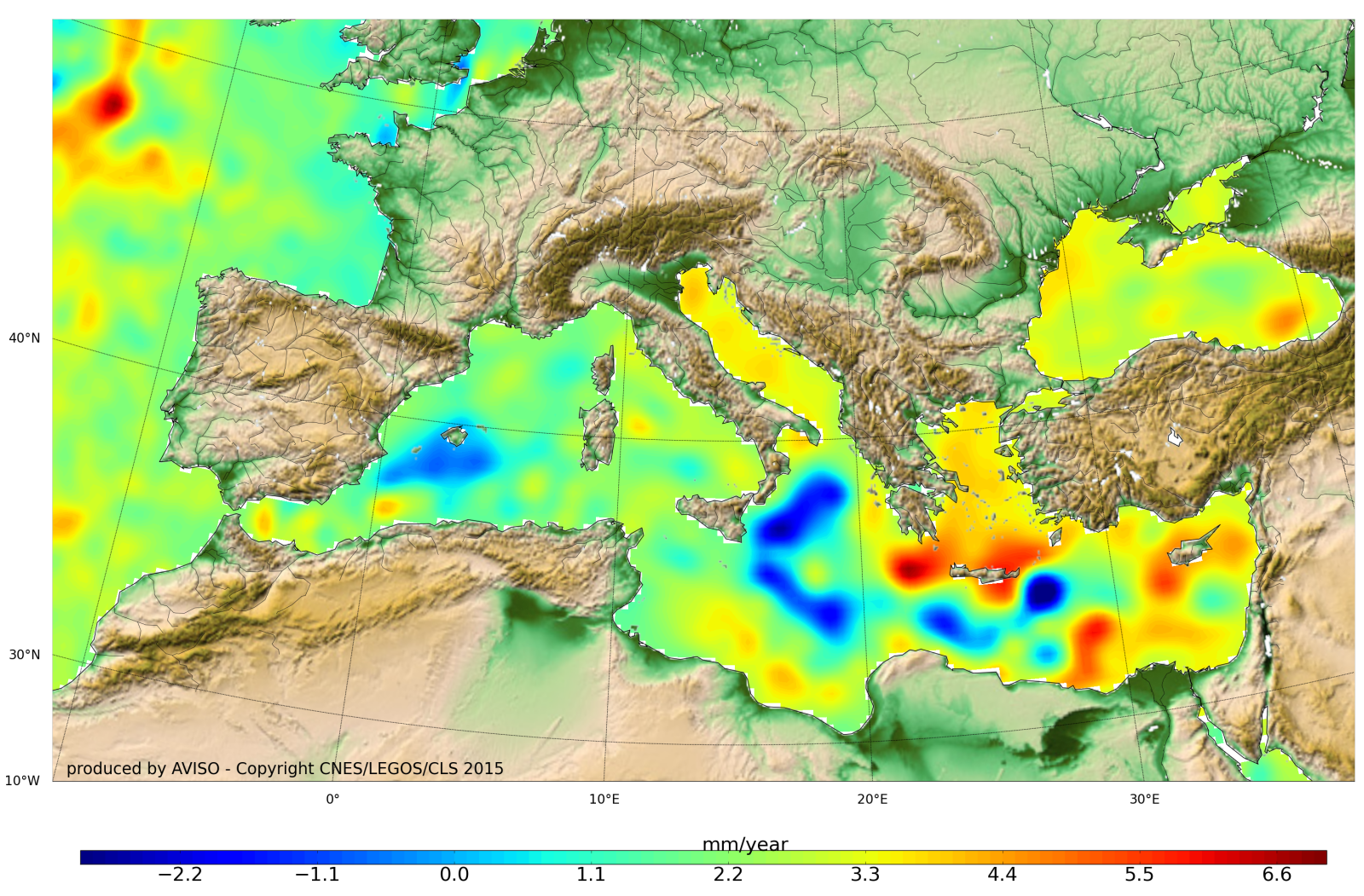
[image credits: CNES/LEGOS.CLS]
Benefits to society [link to http://sealevel.jpl.nasa.gov/science/societalbenefits/]
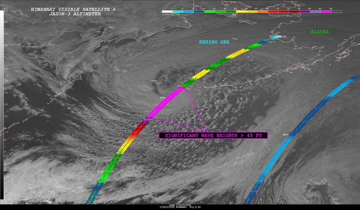
Jason-3 detected phenomenal significant wave heights to 58 feet (17.6 meters) just south of the Aleutians during a storm in October 2017. [image credits: NOAA National Weather Service Ocean Prediction Center]
For more information on Jason-3, please visit:
www.eumetsat.int
www.nesdis.noaa.gov/jason-3/
www.aviso.altimetry.fr/fr/missions/current-missions/jason-3.html ou
https://sealevel.jpl.nasa.gov/missions/jason3/
About EUMETSAT
The European Organisation for the Exploitation of Meteorological Satellites is an intergovernmental organisation based in Darmstadt, Germany, currently with 30 Member States (Austria, Belgium, Bulgaria, Croatia, Czech Republic, Denmark, Estonia, Finland, France, Germany, Greece, Hungary, Iceland, Ireland, Italy, Latvia, Lithuania, Luxembourg, the Netherlands, Norway, Poland, Portugal, Romania, Slovakia, Slovenia, Spain, Sweden, Switzerland, Turkey and the United Kingdom).
EUMETSAT operates the geostationary satellites Meteosat -9, -10 and -11 over Europe and Africa, and Meteosat-8 over the Indian Ocean.
EUMETSAT operates two Metop polar-orbiting satellites as part of the Initial Joint Polar System (IJPS) shared with the US National Oceanic and Atmospheric Administration (NOAA). Metop-C is the third.
EUMETSAT is also a partner in the cooperative sea level monitoring Jason missions (Jason-2, Jason-3 and Jason-CS/Sentinel-6) involving Europe and the United States.
The data and products from EUMETSAT’s satellites are vital to weather forecasting and make a significant contribution to the monitoring of environment and climate change.
The European Union has entrusted EUMETSAT with exploiting the four Sentinel missions of the Copernicus space component dedicated to the monitoring of atmosphere, ocean and climate on its behalf. EUMETSAT carries out these tasks in cooperation with ESA and already exploits the Sentinel-3 marine mission.
EUMETSAT has established cooperation with operators of Earth Observation satellites from Europe and China, India, Japan, Russia, South Korea and the United States.
Media Relations EUMETSAT:
Tel: +49 6151 807 7320
Email: press@eumetsat.int
www.eumetsat.int
About CNES
CNES (Centre National d’Etudes Spatiales) is the government agency responsible for shaping France’s space policy and implementing it in Europe. Its task is to conceive and orbit satellites, invent the space systems of the future and nurture new services to aid us in our daily lives. Founded in 1961, it is the initiator of major space projects, launch vehicles and satellites, and the partner of choice for industry fuelling innovation. CNES comprises some 2,500 men and women with a passion for space working to open up new and infinite fields of applications in five core areas of focus: Ariane, science, Earth observation, telecommunications and defence. It is a key player driving technology innovation, economic development and industrial policy for the nation. It also fosters scientific collaborations and has forged numerous international partnerships. France, represented by CNES, is the leading contributor to the European Space Agency (ESA).
CONTACTS
Pascale Bresson Press Officer Tel: +33 (0)1 44 76 75 39 pascale.bresson@cnes.fr
Raphaël Sart Press Officer Tel: +33 (0)1 44 76 74 51 raphael.sart@cnes.fr
Sébastien Martignac Press Officer Tel. +33 (0)1 44 76 78 35 sebastien.martignac@cnes.fr